eophysics is the study of the magnetism, electricity, radioactivity, vibration, fluid dynamics, gravity, and mineral properties of the Earth. From laboratories in Fairbanks, researchers at the UAF Geophysical Institute (GI) gather data in Alaska to unlock the secrets of the entire planet.
Some of those laboratories look outward to space, including the Alaska Satellite Facility, the Poker Flat Research Range where sounding rockets are launched, and the High Frequency Active Auroral Research Program for studying the ionosphere.
Other laboratories help protect the state from natural hazards, including the Alaska Earthquake Center, the Alaska Volcano Observatory, the Alaska Climate Research Center, and the Arctic Coastal Geoscience Lab.
And parts of the institute connect with the original mission of the university, when it was founded in 1917 as Alaska Agricultural College and School of Mines. At the time, Fairbanks was barely more than a trading post for prospectors who flocked to the area during the 1902 gold rush. Modern-day prospectors have a high-tech assist from the institute’s Hyperspectral Imaging Laboratory, Geochronology Laboratory, and allied research groups.
“This affects our operations in two areas,” says Sean Regan, assistant professor of geology and director of the Geochron Lab. “We now can analyze things with a greater precision at a higher throughput.”
According to Regan, every rock tells a story. The Geochron Lab measures the age of rocks and minerals using an argon method: researchers irradiate samples with neutrons in a nuclear reactor, changing some potassium into argon. This technique results in precise dating accuracy. The lab also offers mineral extraction services for rock samples in preparation for dating.
Establishing the age of minerals and rocks is a major step in determining the formation history of mineral deposits. Regan says this provides a framework for understanding how the specific regions developed and what geological processes resulted in mineral deposits. With that framework in place, researchers and mining companies can evaluate the combinations of critical geological processes required to distribute ore deposits at all scales.
Even with the latest technology driven by years of expertise, the Geochron Lab still finds dating “young” samples a challenge. The decaying system that makes the argon method successful isn’t as pronounced in younger rocks as in samples with a longer history. Likewise, samples also include mixtures of materials, which can lead to grain inclusion in the analysis. To ensure they are only studying relative materials, the lab acquired a micro computed tomography system, like a hospital CT scanner combined with a microscope, that uses X-rays to build a 3D image, slice by slice.
“We go down the list from readily available materials like aluminum and discuss more limited elements like cobalt and lithium used for circuitry and rechargeable batteries,” says Regan. “When you think about how many smartphones are made annually, we need to think about the sources of critical minerals.”
As of 2022, the US Geological Survey identified thirty minerals imported for domestic manufacturing. Of those thirty, the United States is 100 percent reliant on the import of twelve key minerals, seven of which come from China.
However, identifying sources of critical minerals doesn’t guarantee that mining companies will receive permission to extract them. Mining companies undergo an intensive, time-consuming public process at the start of the mining cycle and must continue to adhere to multiple regulations throughout development, production, and land reclamation.
“Alaskan officials and lawmakers are pushing to increase resource development,” says Martin Stuefer, director of the GI’s Alaska Climate Research Center. “Mining’s future will depend on public and administrative support and the enforcement of regulation and environmental laws. Alaska already supplies around 70 percent of US zinc production. We also produce significant amounts of gold, copper, and lead in the state. Hopefully, we find a balance between mining and the environment.”
“The nice thing about this method is that we can locate minerals without destroying anything,” says Stuefer. “Before, companies would have to go in with machinery and drill into the ground. And though that is still needed in later stages of exploration, we can fly over an area and find the best location before they go in.”
JR Ancheta | UAF | Geophysical Institute
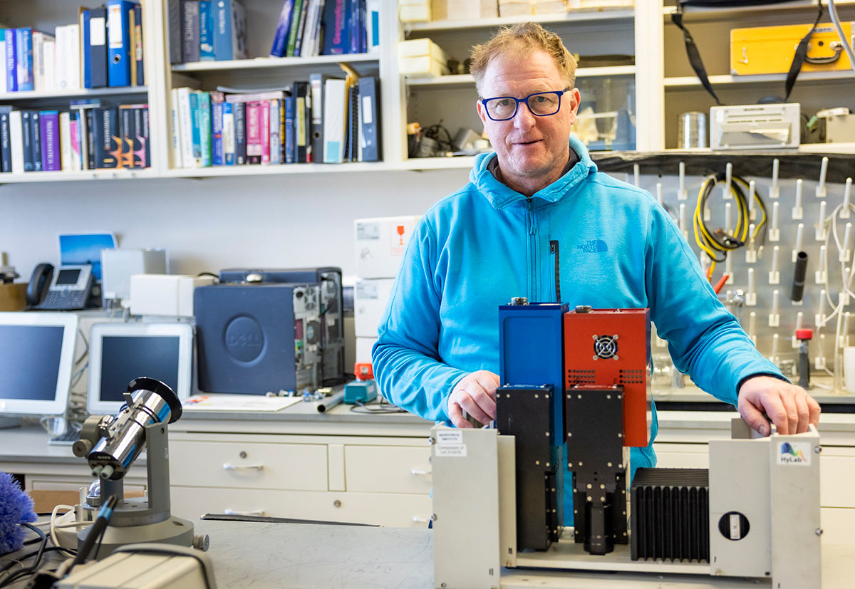
The main instruments in Hylab are the HYSpex VNIR-1800 and SWIR-384 cameras and a PSR+ from Spectral Evolution. Both are high-speed cameras that have low stray light levels, low sensitivity to polarization, and low spectral distortion and spatial distortion. The cameras also have automatic electromechanical shutters for dark offset. The PSR+ unit has three separate detectors measuring the full spectrum from ultraviolet to near infrared.

JR Ancheta | UAF | Geophysical Institute
The wavelengths that hyperspectral imaging captures are extensive. The optical sensor on a smartphone camera captures three channels (red, green, and blue); in comparison, hyperspectral imaging captures 460 channels, including infrared. Since measurements are based on reflectivity, the ideal surveying conditions are sunny, cloudless days in areas with low vegetation. Stuefer says conducting surveys in less-than-ideal conditions results in low-quality data that is essentially no good.
In a nutshell, AIL takes a material sample and determines the number of mineral crystals and, in the cases where more than one mineral is detected, the proportion of each type. Of the seven instruments in the lab, AIL Director and Associate Professor Menghua (Marty) Liu says four machines are frequently used for this type of analysis.
The JEOL JXA-8530F electron microprobe (EPMA) is the workhorse of the lab, as it identifies the composition of any material, including minerals, steel, and ceramics, to its exact location within the sample. This quantitative analysis can also provide percentages of the composition, while a different function on the machine uses X-ray mapping to provide a detailed distribution of the sample. The electron microprobe is the only one of its kind in Alaska. An NSF grant funded its acquisition in 2013—a major upgrade that allowed AIL to expand the services it provides.
The FEI Quanta 200 environmental scanning electron microscope collects similar data to the EPMA; however, it can be operated in a regular low-vacuum and full environmental mode that allows the lab to image wet, uncoated samples and samples that are heated and cooled on a device known as the Peltier stage. The PanAlytical Axios X-ray fluorescence spectrometer is used for quantitative analysis of bulk samples, and the PANalytical X’Pert material research diffractometer is used to look at thin, crystallized, and powdered materials and identify their components.
Liu says field accuracy completely depends on fully understanding what researchers, government entities, or companies want to know. “Our analytical approach is based on the question,” says Liu. “The benefit of our services is that we ask questions about their needs, the problems they want to solve. A lot of commercial labs don’t do this.”
He says the best way for the GI’s labs to investigate rich questions is by introducing all the instruments to interested parties and explaining what they can do.