n the aftermath of Typhoon Halong last fall, emergency management officials examined the storm’s damage in a swath from Kuskokwim Bay to Nelson Island, all without setting foot on the ground. From a thousand miles away they assessed the situation in western Alaska thanks to the deployment of drone aircraft.
“Instead of trying to get personnel out to assess all these areas, you have the drones that are able to assess all of this infrastructure in real time,” said Stan Caldwell, director of the US Department of Transportation’s Strengthening Mobility and Revolutionizing Transportation grants program. He added that evaluating damage to roads, bridges, and other infrastructure in harsh winter conditions took hours, rather than days, thanks to the use of drones.
The future is now when it comes to technological solutions for Alaska’s transportation challenges.
Government departments, researchers, contractors, and private companies are using new technologies to improve all aspects of transportation, including addressing the needs of and creating greater connectivity among communities off the road system.
On the other hand, operating a drone takes only two people. One pilot operates the drone, and a second pilot assists for safety reasons. Before additional personnel are deployed, decision-makers thousands of miles away can use information gathered by the drone to decide exactly how many emergency responders they should send to each affected area.
In the aftermath of Typhoon Halong, drones provided an up-close view of damage for specialists back in Anchorage by creating an “orthomosaic,” a single, giant, highly detailed, high-resolution image.
This imagery and data created a “common operating picture” that DOT&PF and other state and federal agencies worked from to identify needs across the communities affected by the typhoon. Sharing a single, consistent understanding of the situation in western Alaska, Langley says, led to a significantly more rapid response than past disasters have seen.
“Ultimately, our people doing cost estimates from that data rolled up to the state receiving a disaster declaration… in a shockingly fast time, compared to the average,” she says.
Deploying drones in the wake of disaster also creates a permanent recording that provides a point of comparison, allowing researchers to track storm damage and the effects of climate change year to year. Being able to compare before-and-after images of a particular region or village can help the state mitigate against future disaster.
Prior to using drones, DOT&PF crews would drop explosives from helicopters to set off avalanches. Drone technology provides a cheaper and safer option and can be deployed in shorter weather windows than helicopters can.
To cause a controlled avalanche as a preventative measure, drones drop explosive canisters. Recently, DOT&PF succeeded in producing an “air blast” from its drones, activating an explosion roughly two meters above the ground to create a high-pressure shockwave that triggers a slide; prior to this, the explosive would only be detonated once it hit the ground. Air detonation “moves a lot more snow in a hurry,” Langley says, and is ideal for targeting avalanches in remote places at high elevations.
For avalanche danger closer to Alaska’s roads, in the past DOT&PF relied on access to howitzer cannons on loan from the US Army. Today, crews can roll out a second type of technology: mobile Boom Whooshes that use a combination of propane and oxygen to blast air to trigger avalanches at lower elevations. This winter, Boom Whooshes were used in Thompson Pass and in Girdwood to prevent snow from burying highways and utilities.
Avalanche detection has also taken a leap forward, thanks to new uses of technology. Doppler radar, which visually tracks an avalanche’s path, and infrasound, which detects avalanches based on sound waves, were both installed along the Seward Highway this year. Both methods can alert drivers to avalanche danger through an app on their phones. Future use will include an automated system of traffic lights that can warn drivers on the road, as well.
This technology could provide an alternative for transporting goods and people as air carrier prices grow unaffordable. In places like Teller, people already use trail systems to reach Nome in the winter, but bad weather makes the trip dangerous.
“In Teller, a storm can blow in, and you’d better have all your safety gear with you,” Connor says. “We want to minimize that danger.”
CSET is funding radar technology along trails that will make terrestrial transportation safer in the winter. Some communities are also investing in the effort, creating greater connection between villages.
“This idea of being totally isolated is wearing thin, especially on the younger generation,” Connor observes.
Technology doesn’t always look like robots and computer imaging. For ground-level innovations, CSET is exploring new materials and methods for stabilizing soil that might allow for construction of roads in Alaska’s remote locations.
“We can take the soils we have that are not quite good enough to build roads, treat them, and make them usable without having to haul [gravel] in,” Connor says. Such a breakthrough would be a game changer for enlarging Alaska’s road network.
A new form of insulation may be the solution for building roads over permafrost, he adds. Regular insulation guards against both cold and heat; in the summer, this means it only slows the rate of thaw, rather than keeping the permafrost frozen. A patent-pending option, created by strategically drilling holes in the insulation to create air convection cells, can keep permafrost frozen throughout the year, allowing construction of roads over permafrost that will not thaw.
“It’s kind of magic, but it works,” Connor says.
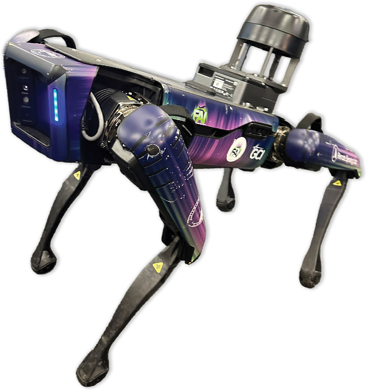
For now, Aurora has another job at FAI: wildlife mitigation. In 2024, the robot began patrolling for animals on the runway. Every year, wildlife, especially waterfowl, cause incidents for aircraft landing and taking off from Alaska’s airports.
Last year, Alaska aircraft experienced ninety-four wildlife strikes, including ten at FAI. While most of them caused no damage to aircraft, the danger to wildlife can be significant. In 2017, the pilot of a Boeing 737 aborted a landing at Deadhorse Airport to avoid a caribou on the runway—but not in time to avoid striking and killing the animal with the aircraft’s landing gear.
Typically, people are employed to monitor runways and chase wildlife away. The robot dog, though, comes with distinct advantages: It never needs a break, can work around the clock, and if it encounters a surly bear or a spooked caribou, it’s more likely to come out unscathed than a human.
Robots have another advantage over humans—they don’t need to breathe. A second type of robot, Archimedes, is aiding DOT&PF in monitoring Alaska’s docks and piers, allowing operators on shore to determine the condition of underwater infrastructure before sending a diver down for repairs.
“Even if we have a diver en route, we can send a remote-controlled robot down, and it allows us to see what the situation underneath is,” Langley describes. “That way, the diver is better prepared for what they’re about to experience.”
The question is, what to do with all this information?
“Innovation happens in a lot of non-Boom Whoosh ways,” Langley said during a presentation for the Alaska House Transportation Committee in March. She highlighted the digital tools DOT&PF is using to compile and share information among stakeholders and with the public.
One example she shared is the Alaska Statewide Transportation Improvement Program (STIP), the state’s four-year program for transportation system preservation and development. The STIP amounts to a 400-page document replete with valuable information.
But “it can be hard to read,” Langley admits. But thanks to DOT&PF’s expanded geographic information team, the STIP is now a digital tool that can organize data compiled from multiple sources. “If you want to look by a strategic investment area, if you’re interested in your particular district, if you want to know your community, if you’re after things that are on the Glenn Highway—you can search for all of that information and not only know what is coming but get a comparison of how the STIP changes over time.”
Other digital tools similarly make information transparent and useful to the public. DOT&PF’s 511 “Know Before You Go” website provides up-to-the-minute traffic and transit information for Alaska drivers based on reports from transportation personnel and from Road Weather Information System cameras.
The cameras also funnel information to the state’s winter operations dashboard, which tracks where maintenance vehicles have cleared roads and how fast traffic is flowing along specific corridors, an indicator of how comfortable drivers are in current conditions.
The typhoon dashboard, in particular, demonstrated how technology can get disparate stakeholders on the same page, to the benefit of the communities in need of help in the storm’s wake.
“We were able to create a common operating picture for DOT and other agencies at a state and a federal level. And that allowed us to reduce resources across the state, but also to start identifying what were the needs,” says Langley. “By feeding that data in, our designers and the other people who were doing cost estimates could grab that information and start working with the State and FEMA.”
Two years ago, DOT&PF first established the Data, Modernization, and Innovation office, which Langley now runs, in an intentional effort to use the data gathered by advanced technologies. More information is out there and ready to be used. For instance, Lynden trucks outfitted with Starlink satellite internet connections have begun to contribute updates to DOT&PF’s 511 website. “Alaska Alerts” will create geofences that allow responders to send messages directly to cell phones in a specific area to message travelers about poor conditions or provide emergency assistance.
As additional technologies and new sources of information become available, Alaska has the potential to stay on the forefront of how these tools are being used, muses Connor.
“We can do so much, and we’re still learning how to use the technologies that we have,” he says. “Our limitation is really only in our mind.”