Site Assessment
Surface soil sample collection.
Environmental Management Inc.
Site Assessment
Ravn Air Group
o two environmental site assessments are the same. Organizations and individuals request assessments because of specific needs unique to the circumstances of their particular project. Environmental site assessments are most commonly used to determine the risks of contaminants on a property, and some projects require a more thorough assessment to be completed due to the history of the site.
Environmental site assessments are generally requested during the early stages of a transaction process, as the involved parties typically view the assessment as a part of the “due diligence” period before the transaction is complete, so the majority of Phase I site assessments occur before a property changes ownership. If contamination risks are identified and need remediation, the site would require a Phase II site assessment to clean up the contaminants.
Site assessments are generally requested by organizations or individuals planning to purchase or sell a property, and the bulk of environmental site assessments are completed by environmental consulting firms that specialize in the field. Many of the consulting firms in Alaska work in collaboration with financial institutions that suggest site assessments take place when a client is preparing to refinance a property.
“Environmental site assessments are a due diligence tool that potential buyers and sellers of properties can use to assess environmental risk that can impact the value of a property,” says Matt Hemry, vice president for Shannon & Wilson, a geotechnical and environmental consulting firm with offices in Anchorage and Fairbanks. “There’re a couple different scenarios. A potential buyer or seller of a property sometimes likes to know this information for their own education of what’s there. But a lot of times it’s driven by a financial institution requiring a test as a part of their financial project. The bank, financial institution, or investor is going to be on the hook if there is an environmental contamination found at a later date and they haven’t done their due diligence.”
A worker conducts groundwater sampling in Kenai.
Shannon & Wilson

A worker conducts groundwater sampling in Kenai.
Shannon & Wilson
“If you’re doing water sampling and have deep water wells, you might be able to sample year-round. If it’s shallow water and you’re having to poke through ice, you are kind of limited.”
–Shayla Marshall
Senior Program Manager
Environmental Management, Inc.
The first step is a Phase 1 site assessment to evaluate what, if any, environmental risks exist on the property. One of the first measures in that process is to learn about the history of a site and what the property was used for in the past. The Department of Environmental Conservation’s (DEC) databases, which include data on contaminated sites, spill sites, and registered underground storage sites, are a good place to start.
“Each database has a prescribed radius that we have to look at,” explains Bob Braunstein, president of BGES, a full-service environmental consulting firm. “For national priority lists, it’s a mile radius. For registered tanks, it’s just the property and the adjacent properties. For some of the other databases, it’s either a half mile or a quarter mile. There’s roughly about a dozen databases that we look at.”
Some sites, particularly those in remote parts of the state, don’t have much documented information in the DEC’s databases. According to Braunstein, having little information to work with isn’t necessarily a bad thing. “Finding nothing in the databases is a good thing—that means there’s no reported contaminated sites nearby,” he says.
When a search of the databases doesn’t produce results, consulting firms spring into action to conduct their own reconnaissance to discover more about the site’s history. Although consulting firms employ scientists that are versed in identifying contaminants, their research is often completed with the help of others, especially when a site is in a remote part of the state that isn’t easily accessible.
“There are outfits that specialize in aerial photography and they’ll encompass the state,” Hemry says. “We can go into their office and say, ‘Can I see aerial photographs showing this parcel dating back to the 1950s?’ We’ll choose one from 1950 and maybe another from 1960, and we’ll see what’s going on with the site and start honing in on what we’re interested in. We’re certainly interested in any type of development.”
Firms can often spot contaminants just by viewing photographs. The easiest indicator of contaminants is discolored or dead vegetation, or sometimes a spill is very visible. Even if the site isn’t visibly contaminated, photographs can help identify other features that may indicate a risk.
Groundwater sampling at Brooks Lake in Katmai National Park and Preserve.
Ahtna Engineering Services

Groundwater sampling at Brooks Lake in Katmai National Park and Preserve.
Ahtna Engineering Services
President, BGES
“If there are cracks in the surface, that could allow contamination to migrate to the subsurface,” Hemry explains. “One of the other big things we look for are vent pipes—or fill pipes—that might indicate the presence of an underground storage tank. We also go inside of the buildings, typically in the boiler room: even if it’s been converted over to natural gas, there still could be old return lines or copper pipes that extend into the walls. That’s usually a good indication that there’s an old tank there. If there’s an old tank, we’re obviously concerned about the potential of a leak in the past.”
BGES also reaches out to gas and water companies to learn when a specific site first connected to those services. Braunstein notes that, if a property was constructed before natural gas was connected to the property, there’s a good chance an underground storage tank was once present and utilized for heating fuel.
Although the risk of present contaminants is almost always identified during Phase I environmental site assessments, they aren’t required for every property transaction. And, even if a contaminant is present, it doesn’t mean a Phase II site assessment will be necessary.
“Just because we identify an obvious risk or a potential risk, that doesn’t necessarily mean something needs to happen,” Hemry says. “At that point, the controlling party of the site can make a business decision, based on their risk tolerance, whether or not additional action is needed.”
In order to make a decision about additional actions, it’s important to know which contaminants are present and what kind of risks they pose. Environmental Management, Inc. Senior Program Manager Shayla Marshall says her firm often evaluates dangerous contaminants by looking at their exposure pathways. “We ask: How can somebody get sick from that contaminant? Is it in an area that’s right along a waterway where people go fishing, or is there a drinking well on site and is the contamination getting into the drinking source?”
Marshall also notes that wells are a driving factor for determining the potential risk of contaminants and that vapor intrusion has become a bigger issue throughout the state during the past fifteen years. “If you have contamination below a building you are working or living in, can that contamination potentially go up into the structure where you can breathe it and get sick? Where is it going, and is somebody being exposed to it on a daily basis but is unaware because you can’t see it, smell it, or taste it?”
Vice President, Shannon & Wilson
Although environmental site assessment consultants widely agree that the state’s most common contaminants are from petroleum-related gases, there are other contaminants routinely found.
“One thing that comes up all the time in Alaska soils is arsenic,” Braunstein says. “It’s naturally occurring and it exceeds the DEC cleanup criteria. The DEC becomes concerned with arsenic if it’s from what appears to be a potential man-made source.”
It’s one thing to identify the dangers of various contaminants, but what about cleaning up the site?
That’s where things can get tricky.
After consulting firms identify the risks—or potential risks—of the contaminants that are present, the property owner determines how to address the situation through a Phase II site assessment. Especially in remote areas, Phase II assessments can be the costliest aspect of environmental site assessments. In addition to driving costs, working in remote areas also forces firms to be creative about how they conduct their work.
Shannon & Wilson
“The interesting assessments are ones that are tough locations that the average Alaskan doesn’t get to go to, like working out on the Aleutian Islands,” says Greg Jarrell, Alaska regional director for Ahtna Environmental. “There’s a string of islands where a lot of environmental work is being done, and that’s interesting because it’s a unique location so the logistics are kind of fun to put together. It’s like putting a puzzle together and hoping you have the right pieces.”

Shannon & Wilson
How to treat contamination can also be a puzzle. Braunstein describes a recent Phase II assessment that BGES is currently working on that is particularly interesting because of where contaminated vapors were found.
“Sometimes you have deep contamination,” Braunstein says. “We have a project in Peter’s Creek where contamination extends down to about 145 feet. So obviously it’s not feasible to excavate. What we’re doing is we put in a solar vapor extraction system that basically sucks the air out of the soils with a vacuum. It pulls out the vapors over time and can take several years to reduce the soil concentration to acceptable levels, but that’s the most feasible way to deal with a deep contamination. It’s not inexpensive, but when you deal with contamination that deep, it’s about the only way to deal with it.”
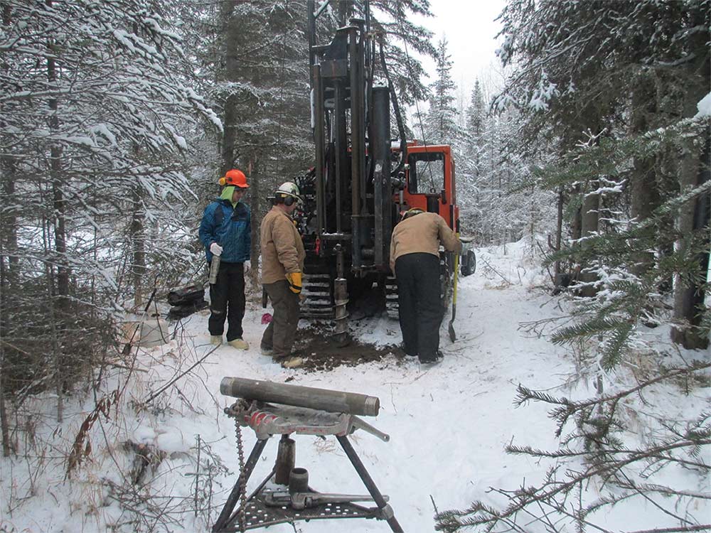
As it is for all of Alaska’s major industries, the state’s long, dark, cold winter season is also challenging.
Environmental Management, Inc. worked atop a mountainside in the Interior this past November, a project that required the firm to helicopter in a rig so it could drill in the middle of a blowing snowstorm. “It all depends on the equipment being used,” Marshall says. “That dictates what you’re able to do with soil sampling. If you’re doing water sampling and have deep water wells, you might be able to sample year-round. If it’s shallow water and you’re having to poke through ice, you are kind of limited.”
Regardless of what an environmental site assessment requires, the scientists involved are pleased to be a part of the industry.
“I find it to be a very interesting field in that—more than other consultants like engineers—we are a real mixed group,” says Nino Muniz, a senior program manager for Ahtna Environmental. “It’s an interesting field because there are so many components of so many different kinds of sciences that you use to try to do this work. A civil engineering group is going to do civil engineering design; a mechanical engineer is going to do mechanical engineering design, but we put all that stuff together. ![]()