he valuable mineral deposits investors have brought online or are attempting to bring online in the Last Frontier usually stand out for their mammoth size. There is the Red Dog Mine, the largest zinc mine in the world; there’s the Donlin Gold project, which is one of the largest known undeveloped gold deposits in the world; and then there’s the controversial Pebble Project, which constitutes one of the largest copper and gold discoveries in the world.
“In Alaska, people are looking for elephants, because it’s easier to develop elephants—they are more economical,” says Jennifer Athey, geologist and lead data manager for the Alaska Division of Geological & Geophysical Surveys (DGGS). In the mineral exploration industry, “elephant” is a shorthand term for extremely large deposits. Athey points out that the magnitude of such deposits allows for the construction of roads and other infrastructure needed to bring a mine online.
“The nice thing is Alaska has elephants to find, and it also has a lot of smaller deposits, too,” Athey says. “So if that infrastructure is developed over time, then we’ll be able to economically develop some of the smaller prospects as well.”
“There’s only a very small part of eastern Interior Alaska that is actually part of ancestral North America; everything else has been stuffed onto it over time,” says Curt Freeman, the founder of Avalon Development Corp. and an exploration geologist based in Fairbanks. “You’ve squeezed fifty different terranes into one area the size of Alaska, 365 million acres. Very few places on earth have that kind of density of different geologic terranes, and that’s why you have gold in some areas, copper in some areas, rare earth elements, et cetera.”
The geology in the state is often described as a jigsaw puzzle of chunks of terranes—islands and fragments of the continental crust—that have been glommed onto Alaska over the last 200 million years.
“What you do end up having in Alaska is a huge hodgepodge of terranes: little pieces of this and that all colliding with each other like bumper cars,” explains Sue Karl, a geologist who has been with the US Geological Survey in Alaska since 1977.
These collisions are a result of tectonic movements in the Earth’s crust.
“A key term that defines Alaska geology is tectonics. Tectonics means the juxtaposition of various types of rocks by different kinds of faults,” Karl explains, pointing to three primary types of faults that have defined the geology of the state. These are thrust faults, by which rocks are stacked on one another, including the subduction of oceanic crust below continental crust; strike-slip faults, which involve blocks of rock sliding past one another and are the source of most near-surface earthquakes Alaska; and normal faults, which occur where the Earth’s crust is extending and being stretched thin.
In some systems, like the one that created the Greens Creek deposit, hot water-based fluids are responsible for transporting valuable elements from deep in the crust up along fractures and faults toward the surface. As the fluids rise, they encounter changes in chemistry, changes in temperature, and changes in pressure, which eventually result in minerals crystallizing out of solution, forming deposits.
“It’s important that the water contain significant amounts of either chloride or sulfide ions in order to transport the gold. Hot water by itself won’t do anything,” notes Rainer Newberry, a retired economic geologist from the University of Alaska Fairbanks. Without those chemicals, the water wouldn’t be able to latch onto the minerals.
“Basically what you’re doing is you’re melting pieces of the crust and they move upward because they’re lighter, and those end up being mineral deposits in different forms in different areas,” Freeman says.
While the general role heat and pressure play in creating these deposits are intrinsic to the formation of metal deposits, the exact way they act on different types of rocks in different environments lead to different geological models.
There’s enormous variety in the types of deposit models found in Alaska, Athey explains. The robust modeling systems help geologists identify indicators of valuable mineral deposits. These could be as straightforward as knowing to look for trace amounts of gold, silver, or bismuth in soil samples or searching for tin, tungsten, and fluorite in the tin-granite systems on the Seward Peninsula.
“I think the key to a lot of this is that the geology for Alaska has just been so dynamic over many, many, many years and has produced a lot of these things,” Athey says.
For example, there are quartz-vein hosted gold models, as seen at the Pogo and Kensington mines; intrusion-hosted gold models, as seen with Fort Knox; sediment-hosted massive sulfides models, as seen with the Red Dog Mine; and volcanogenic massive sulfides models, as seen at the Greens Creek mine and the Palmer and Niblack exploration projects in Southeast. “There’s other different kinds of ore deposit models, and different deposits in Alaska,” Athey says.
Once exploration geologists know what type of mineral they want to search for, they need to review regional maps to identify the types of geological models that are in the region they are interested in, explains Freeman. The model gives geologists a better idea of what clues to look for.
At their essence many geologists are Sherlock Holmes-style investigators. They collect clues from the surface rocks, from core samples, from chemical analysis, and they develop a story or thesis—founded in hard evidence—for what is beneath their feet and why it’s there. The models they determine provide the framework for understanding the geological history of an area.
Jonathan Caine| USGS
Jonathan Caine| USGS

“It just takes a long time to build up that repository of information,” Athey says.
Various agencies, including USGS, Bureau of Land Management, and DGGS have been working to piece it all together.
“If you look at a lot of the geology in the Lower 48, and in places like Great Britain, and other places around the world, they’ve got it so figured out that they’ve moved on to other kinds of products that they can make for people,” Athey says. “Whereas we’re still really doing the initial groundwork. You know, trying to figure out what’s really going on and what’s there.”
A lot of the geologic mapping in the state is forty or fifty years old, Karl points out. “We are updating the maps all the time,” Karl says. “It’s really, really critical to understand how the rocks fit together, how old they are, what kind of deformation and tectonic systems they’ve been affected by.”
This information can be used to create a geologic base map, which helps exploration geologists understand what deposit model might be applicable to an area.
Avalon Development Corp.
Sue Karl | USGS
Sue Karl | USGS

In addition to updating geologic maps for the state, USGS works with partner agencies in developing maps that indicate mineral resource potential. These are created from seven different statewide datasets, including geochemistry, geophysics, and rock types.
“The rock type has a big influence on what kind of mineral deposit might be present,” Karl says. “You can’t figure out how to look for ore deposits if you don’t know what the rocks are, which requires detailed geologic mapping.”
Karl points out the old-timer prospectors covered most of the state, but there is much left to be filled out for on geologic maps.
“They were walking around systematically covering every ridge, every stream, looking for gold or whatever,” Karl says. “There is no place in this state that those old-time prospectors didn’t get to. They were amazing. But mostly they weren’t mapping, and they weren’t figuring out the geology like we can now with all our modern tools and technology.”
The key to accessing mineral assets is as much economic as it is tied to the geological process that created them.
“A deposit that’s perfectly economic in Nevada, and you move it to the Aleutian Islands, and there’s no way in heck anyone can make money off of mining it,” Newberry says. “Enormous deposits are the ones where you can actually make some money.”
Despite economic barriers—and many argue permitting barriers—to bring a mine online in Alaska, the state continues to be a global hotspot for development. “Alaska is special. It is unique. It has a significantly larger endowment of mineral deposits than most places because of its geologic history,” Karl says.
But it’s not just the dynamic geological activity that has produced these deposits that makes Alaska stand out, it’s also all the question marks about what’s actually out there.
“That really is the key to… why there are basically elephants here,” Freeman says. “People come here looking for large deposits because you can still find them sitting on the surface.” ![]()
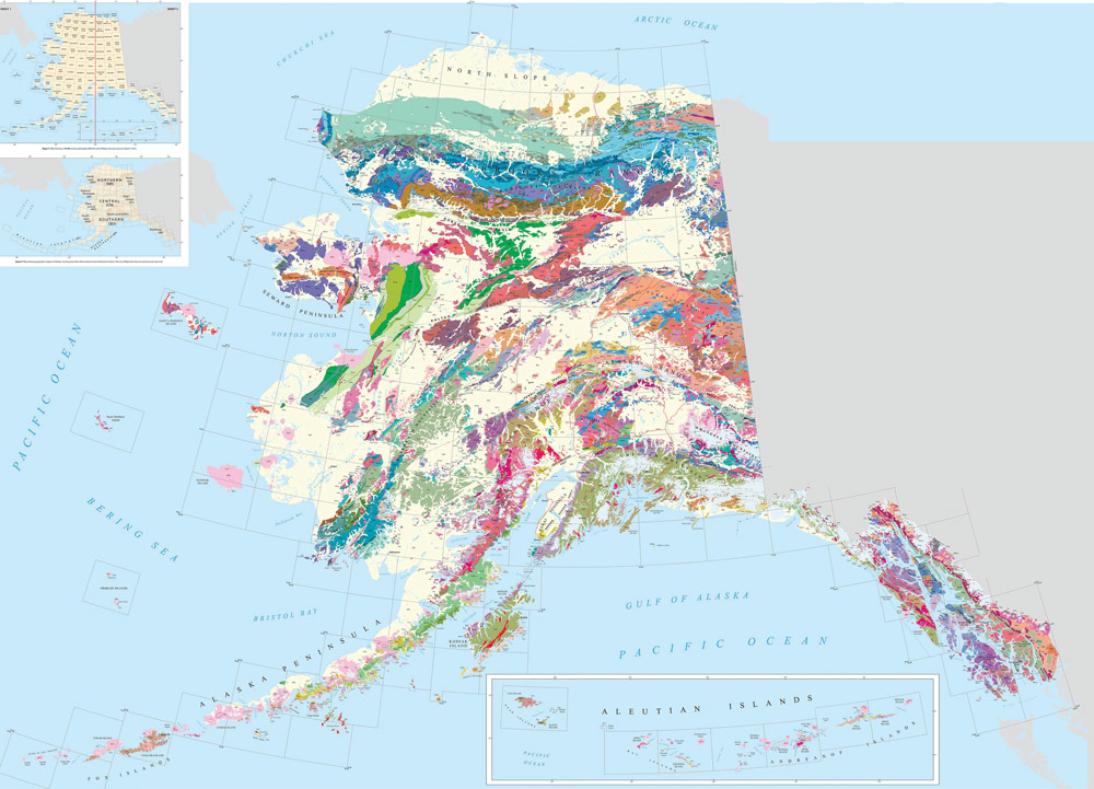
According to Curt Freeman, who founded Avalon Development Corporation, “Fifty different terranes [have been squeezed] into one area the size of Alaska—365 million acres. Very few places on earth have that kind of density of different geologic terranes, and that’s why you have gold in some areas, copper in some areas, rare earth elements, et cetera.”
Alaska’s highly varied geology is illustrated in this USGS map. For example, the large, off white areas represent unconsolidated and poorly consolidated surficial deposits, which may include stream channel and floodplain deposits, beach sands, talus gravels, glacial drift, or moraine. The northern, light teal strip is sedimentary rocks of the North Slope, including the Nanushuk Formation, the Torok Formation, and the Fortress Mountain Formation. Northwest of Dillingham, the teal streak represents the volcanic and sedimentary rocks of southwest Alaska.
To see the map in more detail, including the extensive key, visit usgs.gov/media/images/digital-geologic-map-alaska
USGS | Compiled by Frederic H. Wilson, Chad P. Hults, Charles G. Mull, and Susan M. Karl