Geophysical Institute
and the whole planet
n act of Congress in 1946 launched the Geophysical Institute at UAF. Congress appropriated $975,000 (approximately $14 million today) for the construction and establishment of a geophysical institute, stating, “Because of [the University of Alaska’s] unique location and the work it has accomplished in the past, [it] is a logical site for a permanent geophysical research station.”
The institute’s director, Robert McCoy, echoes that statement decades later. “We’re strongly a function of where we are,” he says. “In Alaska there is a lot of fascinating geophysics… We’re at the crossroads of the ring of fire and the aurora borealis.” He says Alaska’s geography attracts scientists studying volcanoes, earthquakes, sea ice, glaciers, astrophysics, and countless other fields. “Our faculty and researchers travel all over the Arctic; they have the [US] Navy set up ice camps up on the polar ice.”
The institute is not isolated in a lab environment, and the data it gathers and disseminates have value far beyond pure academic research.
“[The name] just rolls off the tongue,” jokes Geophysical Institute Deputy Director Nettie La Belle-Hamer.
“There hasn’t been [a nuclear burst] for decades in the atmosphere,” McCoy clarifies, but there’s still plenty to listen to. “In Antarctica, where it’s pretty quiet, we hear all kinds of stuff,” and the data derived from those sounds is processed and shared.
But what if the network did pick up a nuclear detonation? “We would figure out where it came from and send on that information to the Department of Defense [now the Department of War],” McCoy says. DOW has other listening networks, but UAF, through the Geophysical Institute, is the only university contracted to provide this service.
The network and services required to listen for nuclear bursts is funded through a contract with DOW; in fact, McCoy explains that 95 percent of the Geophysical Institute’s funding comes from federal grants and contracts. A notable exception is the facility’s Earthquake Center, which is funded primarily by the State of Alaska and gathers data during and after earthquakes, including characterizing the earthquake (where, how big, how deep) and its aftershocks.
“There’s 50,000 earthquakes every year in Alaska… and there’s fifty-four active volcanoes,” McCoy says.
Fortunately, the value of monitoring earthquakes, volcanoes, and nuclear bursts is widely accepted. Because those activities comprise much of the institute’s work, it has felt less impact from federal funding cuts than many other science and research organizations that rely on federal grants and contracts.
“I’m always an optimist,” says McCoy. “I think we’re well positioned; the things we do are not controversial.” It’s fortunate for UAF, Fairbanks, and Alaska as a whole, as that means, even in a climate of reduced funding, the Geophysical Institute continues to draw investment to Alaska, both in the form of money and an educated workforce.
La Belle-Hamer, on the other hand, is an example of how the Geophysical Institute creates opportunities for Alaskans to live, work, and raise a family. She was raised in Alaska, and while she traveled out of state for her undergraduate degree, she received her master’s degree and PhD at the Geophysical institute. After completing her PhD in ‘94, she started working on a project at the Geophysical Institute with NASA that continued throughout her career. Last summer, it hit a huge milestone.
In July 2025, NASA launched the NISAR satellite. As McCoy puts it, “It’s a big deal.” NISAR is a synthetic aperture radar (SAR) satellite and was launched from the Indian Space Research Organization’s Satish Dhawan Space Centre. NASA and the Indian Space Research Organization (forming the N and the I in the acronym) partnered to launch NISAR, which is NASA’s first SAR satellite mission since 1978.
NISAR focuses on how the planet’s surface changes from natural and human-related forces, and the mission’s goal is to monitor and measure surface changes such as land subsidence, glacier and ice sheet movement, and shifts caused by earthquakes, volcanoes, and landslides.
The satellite, the most advanced ever, will provide more radar imagery and cover more surface area than other satellites.
“Radar is the really important part of it,” La Belle-Hamer says. “Synthetic aperture means that we get a higher resolution than we normally would… and the cameras work in a different part of the spectrum; they don’t even see clouds; they just see the ground.” The cameras on the satellite can detect change as small as a centimeter on land. “For a volcano, sometimes before it erupts, the land will start to bulge,” McCoy says, and the NISAR satellite can see it.
According to La Belle-Hamer, the United States was a leader in satellite technology and data collection in the ‘70s, but “we haven’t been in the lead since.” The launch, which she had been working toward and anticipating for forty years, is a huge leap forward in earth sciences data collection and dissemination.
Last June the Geophysical Institute signed an agreement with Alaska Aerospace to jointly develop spaceport services to the commercial rocket and satellite industry.
McCoy says that the institute and Alaska Aerospace, in their new partnership, are considering the potential of a launch complex at the northernmost drivable point on the North American road system—Oliktok Point northwest of Prudhoe Bay—which he says would “open up a whole new realm,” and he’s “quietly optimistic” about that project becoming reality one day.
Early this year, the Geophysical Institute, in partnership with the University of Alaska Museum of the North, completed construction of a new planetarium, for which McCoy has advocated for many years.
McCoy says the Geophysical Institute set up a camera to film construction and got a wildlife lesson in the process. “It was for a time-lapse video, but a raven landed on it, beat it up, and tilted the angle,” he says.
While that video didn’t pan out, there are many plans and ideas already in place for the planetarium itself, such as aurora shows, demonstrations of the stars and planets, astronomy lessons, and other science and research-based shows open to the public.
La Belle-Hamer says, “With things like the planetarium, we’re also building intellectual capital here; it’s part of the workforce development… I’m hoping that, those kids who go into the planetarium, there’s going to be at least a few of them that go, ‘Oh! I want to be a scientist.’”
The UAF planetarium is scheduled to open to the public this spring.
The impact of the Geophysical Institute goes beyond direct spending in the nearby area and into remote parts of the state. “We get out on the sea ice north of Utqiaġvik and do observations; we work with people all along the Aleutians,” McCoy says. “We do a lot of travel, and a lot of funding that we get is spread around the state that way.”
In addition to Geophysical Institute researchers, other researchers and scientists traveling to Alaska to take advantage of the facilities or terrain also generate economic benefits, such as the cost of moving equipment and lodging when NASA personnel travel to the state.
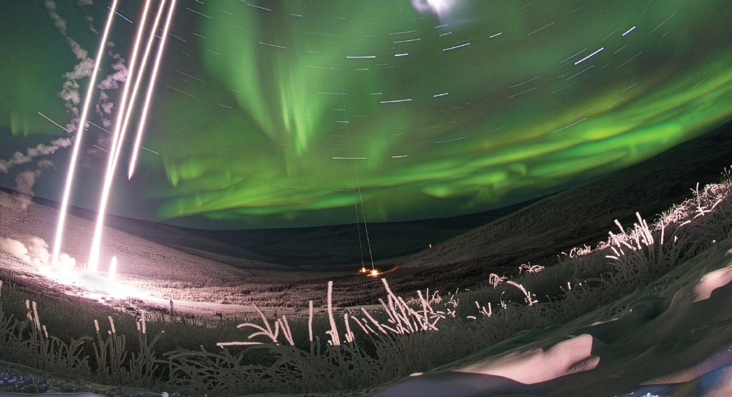
“When we launch rockets, a campaign usually takes about three weeks or more. There might be fifty people that come into Alaska to support that. In the middle of winter, they’re staying in hotels, eating in restaurants,” McCoy says.
“We hire local people to do some of the monitoring for us,” La Belle-Hamer adds.
“We work with the villages and communities—Venetie, Fort Yukon, Kotzebue—and we pay people to set up operational facilities there and man them for us. It’s a win/win, and we’ve been doing it for so many years that we have a really good relationship,” McCoy says.
Beyond research, the Geophysical Institute attracts skilled and educated workers to Alaska.
The Geophysical Institute employs approximately 70 faculty, about two-thirds of whom work in UAF departments teaching undergraduate or graduate students, and it provides research opportunities for approximately 110 graduate student researchers.
“If you look around the Geophysical Institute, you’ll see a lot of Alaskans: a lot of students who came and stayed, and then other people who have come and stayed,” La Belle-Hamer says. “What’s nice about the Geophysical Institute’s growth, and what Bob has brought to the table, is growth across many areas: science disciplines, tech, engineering, software development. It touches a lot of the more modern type of work that people are looking for.”
That 1946 investment is certainly paying off.